Back in 1383, the temple of Wat Phra That Doi Suthep was built on the top of Doi Suthep Mountain just outside of modern day Chiang Mai. Monks had to hike up Doi Suthep to get to the temple, and Wat Pha Lat was later built as a resting place for those Monks. Today, you can still hike the Monk’s trail, stopping for rest at Wat Pha Lat on your journey to Wat Phra That Doi Suthep.

Wat Pha Lat
Typically, the Monk’s Trail is referred to as the part of the trail from the bottom of the mountain (near Chiang Mai Zoo) up to Wat Pha Lat. This is a well travelled path hiked frequently by tourists and locals. It’s a well-marked path with a moderate incline. Most bloggers claim this is a 45 minute hike, however we finished it just 21 minutes (we did not stop for many pictures or breaks and are fit adults in our late 20s).
The hike from Wat Pha Lat to Wat Phra That Doi Suthep, however, is significantly less traveled and much more difficult, both physically and navigationally. There are lots of blog posts out there who provide directions on how to complete this hike, however even after reading as many directions I could find, we still managed to get turned around.

Wat Phra That Doi Suthep
So today, I wanted to share clear and simple directions for getting to the starting point and then hiking from Wat Pha Lat to Wat Phra That Doi Suthep. Both of these temples are absolutely breathtaking, and there is no better way to take them in than to complete the Monk’s Trail.
We just think you should be spending your day taking in these breathtaking views, not glued to your phone trying to navigate your way there like we were. We hope this helps you!
Getting to the Starting Point of the Monk’s Trail
The entrance to the trail is listed as a point on Google maps and is clearly marked from the street. This is all well and good, except the street it’s on is unnamed and no local drivers actually know where this entrance is.
Just take an Uber. There probably are people who can communicate this location successfully to a songthaew driver (we’re not one of those people), but for the price of an Uber (which is actually cheaper for two people), it’s just not worth the trouble. An Uber from the South Gate was 90 Baht and 70 Baht from the North Gate.
When requesting your Uber, enter the destination address for Galae Restaurant. The actual starting point is not a listed address in Uber, and when we tried dropping a pin, the driver didn’t understand. If you use the Galae Restaurant address, the driver should have no issues following their map to the destination.
When you get out, the restaurant will be on your left and the road will curve to your right. Follow the road on and up the hill. When the road ends, you’ll take a short jog left before turning right (near the blue square in the map below). 
At the jog (blue square on the map above), you’ll see a small brick building with a closed gate and a sign in Thai. I’m sorry, but I don’t have a picture of this (at the time, I didn’t realize how much I was going to need to write this post, so I didn’t take all of the pictures). There will be a little barbed wire, but you can pass it easily on the left side. We’re not sure why this gate is here, as the road on the other side is public access, but it is. You might be trespassing, but it’s only about 20 feet before you hit the road, so it was a risk we were willing to take.
Once you get through to the road, turn left and it’s smooth sailing. That road will take you straight to the entrance to the trail. The entrance is clearly marked with a large green map. There will also be a tall red and white radio tower on your right (this is only important to note because you can see it from the top of Wat Phra That Doi Suthep so it’s fun to see how far you’ve journeyed).

Hiking the Monk’s Trail to Wat Pha Lat
Once you’ve entered the trail, the path is clearly marked with orange Monk’s clothes tied around the trees every few yards. The markers were recently redone and very bright, but you can see many older markers which have started to fade and blend into the scenery.

To the left of the statue, you’ll see an orange marker.
The trail is wide and well warn. It’s not an “easy” hike, as there is some incline to it, but it’s certainly not difficult or long. At the beginning, the path is mostly rocky as it makes a gradual incline, but soon gives way to some steeper sections. A lot of the path is steps formed out of tree roots or carved into the dirt and rocks. Be sure to watch your footing.
You’ll see in the map at the entrance that there appears to be two routes. We never actually found any sort of fork in the road, and there is really only one main path. Along the way, you’ll pass a few small wooden signs with some history of the trail. There’s some nice small waterfalls to your left, which you will hear before you see. It’s really a lovely walk.
The path will run into the river, where you’ll get your first glimpse of Chiang Mai city below. Just on the other side of the river, you’ll find the temple of Wat Pha Lat. As I mentioned, most people would put this at a 45 minute hike. It took us 21 minutes.

Once you get to Wat Pha Lat, spend some time exploring the temple grounds. We liked this temple even more than Wat Phra That Doi Suthep because of its serene, hidden-in-the-forest vibe. There’s a small no-name coffee shop, and you should definitely grab an Iced Boon Coffee and sit on the bench and enjoy a quiet moment. Take a minute to regain your energy before the second part of the hike.

Essential coffee stop at Wat Pha Lat
Hiking from Wat Pha Lat to Wat Phra That Doi Suthep
Once you’re done at Wat Pha Lat, make your way back to the river. Keeping the river to your left, continue upward. There is a small, but clear path. It’s quite steep, but mostly on fairly well established natural steps.

This portion of the hike isn’t too long, maybe 400 meters. It took us five minutes. Soon, the path will end at at a road. You will have to climb over the median and cross the street (watch for cars!).

On the other side of the street, it will look like there are two small paths. You’ll want to choose the small dirt path on the right, almost directly across the street from where you just came from. There will be a small sign in Thai from the Thai police near the correct path. We don’t actually know what this sign says, probably enter at your own risk or something, but we kept on going past it.
The path will turn into steps very quickly, and will continue being steps the entire rest of the hike. This path is also marked with orange robes and appears to have been marked pretty recently because they were really clean and bright.

Steps on the path to Wat Phra That Doi Suthep
Parts of this path are more narrow, and while it’s not as well maintained as the path to Wat Pha Lat, you will not likely be the only one on the path (we hiked late, and still past four other groups on this part of the trail). This leg of the hike is much more strenuous, but it is almost entirely steps so it doesn’t feel too challenging. Most people say this part of the hike takes between 70-80 minutes. It took us 35 minutes, taking very few breaks.
The trail will eventually end at another main road. You’ll want to continue up on the main paved road. (Note: there will be a small dirt road to your right, ignore that one. That is a private Monk’s entrance.)
 You’ll follow up the main road for about five minutes and you’ll run into a small village. Along the main street, you’ll find some local Thai restaurants, street food, and lots of shops selling souvenirs.
As you continue, you’ll eventually see a few shrines on your right from street level. Go up the small flight of stairs toward them, and you’ll see a sign pointing you to the temple.

And then you’ll reach your final task of the day: the 309 steps to the top of Wat Phra That Doi Suthep.

At the top of the steps, you’ll have to pay 30 Baht a person for entrance to the temple. It’s absolutely worth it for the golden temple and beautiful views overlooking Chiang Mai.

I hope you enjoy your hike!
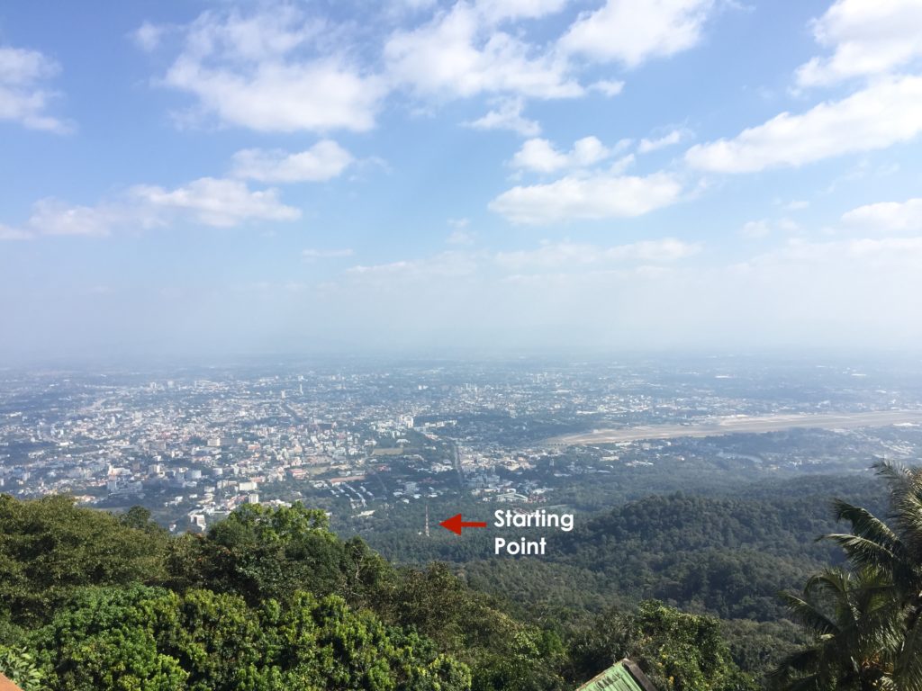
The view of your starting point from the top of Wat Phra That Doi Suthep
Have you taken this trek? Which temple was your favorite?
Bee from Singapore
Wednesday 5th of July 2023
This blog is amazing, it contained exactly what I am looking for!
I am going Chiangmai in Nov, definitely wanted to visit Wat Pha Lat after Doi Suthep.
May I ask whether would be easy to grab a ride from Doi Suthep to Wat Pha Lat and then do the reversed hike to Chiang Mai zoo to catch a songtheaw?
I have a person with weak knee with me, I don't think he can do the upward hike up to Doi Suthep. A 45 minute hike down should be manageable and we get to do sort of an adventure out of the place.
Emily
Thursday 6th of July 2023
Hi! I'm so glad to hear this was helpful! I hope you have a great visit to Chiang Mai!
You shouldn't have a problem getting a ride from Doi Suthep to Wat Pha Lat. I know there were several songthaews near the exit that take people to town, and Wat Pha Lat is on the way. I wouldn't think you'd have a problem getting dropped off at Wat Pha Lat. From there, the downhill hike would probably be okay for someone with a weak knee. It's been a while, but I don't recall it being overly demanding. I would only call out that the trail had (in my experience) doesn't end at the Chiang Mai Zoo. It looks close, but it's a bit south of there and I don't believe has a direct walking route. You'd probably need to call an Uber from here, which would require cell service.
I hope that helps and I hope you enjoy your hike!
Chiang Mai Itinerary: An EPIC 3 Days in Chiang Mai [2021]
Tuesday 12th of January 2021
[…] lost at this point (there aren’t really any signs). Luckily, we had cell service and I found these handy directions […]
Ran Kaori
Tuesday 27th of August 2019
Hi Emily! My name is Ran Kaori and I’m from Viet Nam. I’ll go to Chiang Mai in the end of August 2019. I really expect to walk in Monk’s trail. But I think I can only walk from the end of Suthep Road to Wat Pha Lat. Because the way from Wat Pha Lat to Wat Phra That Doi Suthep is so far with me. After removing from Wat Pha Lat, I can walk about 400m to main road, where I can take a Songthaew to Wat Phra That Doi Suthep. Would you tell me the name of this main road? I think it isn’t Suthep Alley. And if it’s rainy day, I can’t walk in Monk’s trail. Could I go to Wat Pha Lat from this main road? I read many posts on blogs and websites but I still don’t understand the way from Wat Pha Lat to main road to take a Songthaew. If you know the name of this main road, please tell me it. Thank you very much!!!
Emily
Sunday 8th of September 2019
Hi Ran! I'm so sorry I missed this! I think I might have missed your trip. From Wat Pha Lat, you can get to the main road (which from the best I can tell is called Sriwichai Alley). Although, I'm not 100% sure if there are always Songthaews waiting there to take you up to Wat Phra That Doi Suthep. I didn't exit that way, so I'm just not sure. The hike between Wat Pha Lat and Wat Phra That Doi Suthep is actually quite steep. I personally found the first half of the hike to be easier and more beautiful. So I might recommend hiking to Wat Pha Lat, and then seeing if you can catch a songthaew the rest of the way. I'd recommend checking with your hotel or hostel when you get there. They should be able to confirm. Again, I'm sorry if I missed responding to this message in time.
Happy Travels!
Mireille Metwalli
Sunday 12th of May 2019
This was such a helpful post!!! I just got back from the hike and had no issues following the directions and advice. I did find the fork in the path after going in the wrong direction for a few minutes before realizing it wasn’t right. Thanks SO much for taking the time to write this!
Emily
Sunday 26th of May 2019
Hi Mireille! I'm so happy to hear that! Wasn't it such a beautiful hike!? Even more beautiful when you aren't worried about getting lost, like we were our first time! HA! It makes me so happy to hear that my advice has helped some enjoy! Enjoy Thailand!
Sharon
Saturday 22nd of December 2018
I can't wait to do this in a week with my family! Thank you SO much for the detailed directions!! How long do you think from when we get dropped off by the Uber til when we're done at Doi Suthep assuming we are in good shape and will take an average amount of photos and take in the scenery? And how long does it take to get down from Doi Suthep to the South Gate? Are there taxis and Ubers just waiting up there or do I have to arrange ahead of time? Can I realistically think this is a 4 hour excursion from our hotel near South Gate round trip?
Thank you in advance!
Emily
Saturday 29th of December 2018
Oh so fun!! I'm so sorry I'm just seeing this! You're probably making the trip very soon! We were dropped off at the base at 10:45 AM and were on our Songthaew on our way back at 2:34. We spent a decent amount of time at each of the temples and we also got a little lost in the middle. So I'd definitely say that a 4 hour round trip outing sounds just about right! It shouldn't take you more than 30 minutes or so to get from Doi Suthep to the North Gate. There were Songthaews lined up and left as they were filled, so it could be a little longer to wait for your ride to fill up. The fixed price to the North Gate was 60 Baht. At the time, the Songthaews wouldn't take you all the way to South Gate. So you'd have to either walk or jump in a different one in Old City. I hope that is helpful. Have a blast!!